Major Greens
 Lockerley’s four major greens and commons are significant amenity assets providing a focal centre for the communities living around them. The recreational and social life of the village is woven around them. There are two further greens; a new one is located from the green space in Oval Road and there is the tiniest green of all at the top of Tote Hill. Greens are owned by somebody. The Lockerley Parish Council owns Lockerley and Butts greens whilst the others are privately owned by a local farming family or by TVBC.
Despite greens and commons being amply protected by laws and Acts of Parliament, sometimes going back several centuries, no public body is charged by parliament with the responsibility of defending them against encroachment or abuse. Their protection depends mostly upon the willingness of the green owner or of private citizens to take legal action. Most small greens and commons produce little or no income for their owners - they can be more of a liability than an asset - and they have minimal capital value. This gives little incentive to the owner to take expensive legal action to defend them. On the other hand they can have a priceless value to a community by providing open spaces for numerous communal activities - just as the Lockerley greens do. This PDF link provides some outline and examples of the rights relating to declared village greens.
Footpaths
The definitive map of footpaths is maintained by Hampshire County Council (2017). They have a good section on their website dealing with footpaths generally Hampshire footpaths and rights of way. http://localviewmaps.hants.gov.uk/LocalViewmaps/Sites/ROWOnline/, A definitive map can be accessed from this link footpaths in Hampshire. Similar resources exist for other counties including Wiltshire and Dorset.
The english government (2020) is presently asking for notification rights of way that should be present or have not been correctly drawn on the definitive maps to be identified before 2026. This includes paths that have been "lost", erased by landowners or simply fallen out of use and thus memory. Any public space is a premium resource but if such routes have not been identified they will be forever lost. An interesting resource which permits the comparison of the current countryside including footpaths with maps dating from 1895 is available from the National Library of Scotland.
Problems with rights of way - property owners making access impossible or footpaths hopelessly overgrown and not maintained - can be reported. Report footpath problems <http://maps.hants.gov.uk/rowreporting/default.aspx>.
Footpaths dimensions PDF of footpath standards <http://documents.hants.gov.uk/countryside/designstandards-pathwidths.pdf>
Duty of landowner to maintain landowners and footpaths <https://www.hants.gov.uk/landplanningandenvironment/rightsofway/landowners>
Responsibilities of footpath users include reporting unsafe stiles and other obstacles and noting and managing livestock in a field that a footpath traverses, A definitive map can be accessed from this link of definitive map of footpaths in Hampshire. This map does not show the footpaths around the Dean Hill depot that were withdrawn in 1939.
Farmland
The farmland is predominantly improved pasture and arable farmland divided by hedgerows. Several areas of broadleaved woodland are found in this area. Oak is the most common tree species with abundant birch. Ash is uncommon and field maple is rare. Sweet chestnut is also locally abundant and has often been planted as coppice. Other trees found in low frequencies include holly, whitebeam, beech and rowan. Damper soils have alderand poplar.
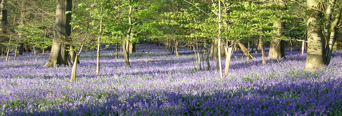
The shrub layers usually have abundant hazel and hawthorn. Ground flora includes bluebell, wood anemone, red campion, honeysuckle, bramble, woodruff, wood sorrel, dog violet, wood spurge, twayblade and greater stitchwort with others such as herb robert and marsh celandine.