Major Greens
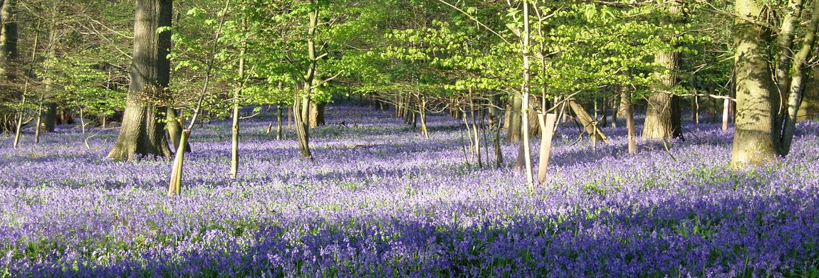
 Lockerley’s four major greens and commons are significant amenity assets providing a focal centre for the communities living around them. The recreational and social life of the village is woven around them. There are two further greens; a new one is located from the green space in Oval Road and there is the tiniest green of all at the top of Tote Hill. Greens are owned by somebody. The Lockerley Parish Council owns Lockerley and Butts greens whilst the others are privately owned by a local farming family or by TVBC.
Despite greens and commons being amply protected by laws and Acts of Parliament, sometimes going back several centuries, no public body is charged by parliament with the responsibility of defending them against encroachment or abuse. Their protection depends mostly upon the willingness of the green owner or of private citizens to take legal action. Most small greens and commons produce little or no income for their owners - they can be more of a liability than an asset - and they have minimal capital value. This gives little incentive to the owner to take expensive legal action to defend them. On the other hand they can have a priceless value to a community by providing open spaces for numerous communal activities - just as the Lockerley greens do. This PDF link provides some outline and examples of the rights relating to declared village greens.
Footpaths
The definitive map of footpaths is maintained by Hampshire County Council (2017). They have a good section on their website dealing with footpaths generally Hampshire footpaths and rights of way. http://localviewmaps.hants.gov.uk/LocalViewmaps/Sites/ROWOnline/, A definitive map can be accessed from this link footpaths in Hampshire. Similar resources exist for other counties including Wiltshire and Dorset.
The english government (2020) is presently asking for notification rights of way that should be present or have not been correctly drawn on the definitive maps to be identified before 2026. This includes paths that have been "lost", erased by landowners or simply fallen out of use and thus memory. Any public space is a premium resource but if such routes have not been identified they will be forever lost. An interesting resource which permits the comparison of the current countryside including footpaths with maps dating from 1895 is available from the National Library of Scotland.
Problems with rights of way - property owners making access impossible or footpaths hopelessly overgrown and not maintained - can be reported. Report footpath problems <http://maps.hants.gov.uk/rowreporting/default.aspx>.
Footpaths dimensions PDF of footpath standards <http://documents.hants.gov.uk/countryside/designstandards-pathwidths.pdf>
Duty of landowner to maintain landowners and footpaths <https://www.hants.gov.uk/landplanningandenvironment/rightsofway/landowners>
Responsibilities of footpath users include reporting unsafe stiles and other obstacles and noting and managing livestock in a field that a footpath traverses, A definitive map can be accessed from this link of definitive map of footpaths in Hampshire. This map does not show the footpaths around the Dean Hill depot that were withdrawn in 1939.
Farmland
The farmland is predominantly improved pasture and arable farmland divided by hedgerows. Several areas of broadleaved woodland are found in this area. Oak is the most common tree species with abundant birch. Ash is uncommon and field maple is rare. Sweet chestnut is also locally abundant and has often been planted as coppice. Other trees found in low frequencies include holly, whitebeam, beech and rowan. Damper soils have alderand poplar.
The shrub layers usually have abundant hazel and hawthorn. Ground flora includes bluebell, wood anemone, red campion, honeysuckle, bramble, woodruff, wood sorrel, dog violet, wood spurge, twayblade and greater stitchwort with others such as herb robert and marsh celandine.
Dean Hill and WWII
 The 243 Ha site of the former Royal Navy Armament Depot (RNAD) is located at Dean Hill on the border of Hampshire and Wiltshire. It is now known as Dean Park and is home to a number of small enterprises. It operated between 1941 and 2004 as a munitions storage and maintenance facility initially for the Royal Navy but, in later times, for all branches of the Armed Forces.
Work began on the site in 1938 prior to the outbreak of WWII and it was opened operationally as RNAD Dean Hill in 1941. At the time a number of footpaths were closed off. The border betwixt Hampshire and Wiltshire runs through the edge of the area (as it does indeed run through the building hitherto known as the Red Lion - it ran between the public and saloon bar - a significant issue when closing times differed in each county). Those paths within Wiltshire were formally closed and recorded as such. Those in Hampshire were not formally closed and, as identified above in the article on boundaries, a footpath is for ever. As a consequence recent attention has been focused on re-establishing the rights of unimpeded access to the footpaths and, at the time of writing in 2017, the proposal has been the subject of an appeal but the desire to see these paths re-established remains strong. The attempt to have these footpaths reinstated on the Definitive Map was rejected by the inspector in 2018 - a cash strapped county council solicitor possibly being no competition against well funded corporation legal resources.
Naval Munitions
A wide variety of naval munitions was kept there before being transported by rail to the forward coastal RNAD locations at Frater in Gosport and Priddy's Hard where they were loaded onto navy vessels for active service. The depot was connected to the main Salisbury to Southampton railway line by a standard gauge railway via a large marshalling yard at the east side of the depot. Munitions were stored in a series of 24 underground magazines cut into the chalk hillside. The magazines were formed of short tunnels built in a curve such that, should there be any accident, any blast might be better contained and would be deflected by berms.
An internal narrow gauge - 715mm - based on bronze rails linked the magazines to the workshops. The workshops, together with a network of laboratories, were responsible for the refurbishment of the weapons they contained and they were heavily protected and reinforced.
Nuclear Munitions
Contrary to popular belief, nuclear weapons were stored there only on a very temporary basis - often little more than overnight. Nuclear weapons were transported by road in large lorries from the Atomic Weapons Establishments at Aldermaston and Burghfield near Reading. The associated nuclear materials were transported from Ministry of Defence reactors at Chapelcross and Calder Hall in convoys supported by detachments of marine commandos and supported by fire service appliances and motor cycle out-riders from the Special Escort Group of the Ministry of Defence Police.
Nuclear weapons were stored in the specially reinforced number 1 magazine and the detachment of Royal Marines were accommodated on their own specially defended block - the number 37 building. The depot and its nuclear associations came to public attention in January 1987 when a lorry containing nuclear weapons skidded off the road on ice near the west gate. How journalists came to hear of it is interesting - this was the era well before mobile phones - but the news was suppressed by what were known as D Notices and the story lives on in local tales. D Notices were a form of government censorship and are hard to implement in the era of Twitter, FaceBook, InstaGram and email.
Throughout the existence of the depot security and crime prevention was provided by its own police detachment of officers from the Ministry of Defence Police. Prior to 1971 this force had been known as the Admiralty Department Constabulary and the Royal Marines Police.
Decommissioning the Site
In 1988 the rail connection to the main line was discontinued. In 1991 RNAD Dean Hill was renamed DM (Defence Munitions) Dean Hill. The entire rail installation, including that of the marshalling yard, was removed in 1994. Following a study by the DM Rationalisation Study team the decision was taken to close the site and its activities were moved to other defence munitions establishments across the UK. DM Dean Hill finally lowered the Defence Munitions and Union flags at the main gate during a sunset ceremony on 31 March 2004.
Lockerley and D Day Preparations
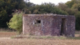
Lockerley was the site of some 15 miles of sidings and a large camp of canadian and american service men. Little evidence of this remains; even the airstrip in the grounds of Lockerley Hall is not mentioned in a review of the WWII airstrips in Hampshire. After the D Day landings the site was restored, very roughly, to agricultural use. In fact so roughly that it can not be used for other than grazing deer. There are some aerial photos of this period and of this area on www.woodleynet.co.uk and a visitor should easily be able to match some of the buildings shown with those extant. One image is the intriguing image of Spring Cottage public house and this too has been identified; it's now a private house in East Grimstead. The area has a number of pill boxes many of which surround the armaments depot at West Dean. Older Ordnance Survey maps showed no detail relating to the depot - indeed, they showed the footpaths and field boundaries of an earlier era. Go to Top
The Lockerley Mechanicals have undertaken a long term project to research this recent but forgotten period. At a recent meeting LIDAR plots of the area of the sidings were shown. LIDAR plots are colour plots which show the subtle changes in land height which can arise due to ancient land use. The LIDAR technology has a resolution of the order of 100mm and it will show the underlying topology of an area independently of existing vegetation and, to a degree, current use. One feature noted in the small area that was shown was the presence of a pathway leading from the site of an early stone age settlement across Critchells Green.
If you would like to add to our knowledge of this period contact the Lockerley Mechanicals or the site admin.
The Mills
 Lockerley Mill – also known as Ford Mill - and Holbury Mill are amongst Lockerley’s listed buildings. Holbury Mill has been the site of a mill for nearly 1000 years and is referenced in the Domesday Book. When it was last in use the undershot wheel was fed from a large mill pond fed by the Dun. The current building is much younger than that and there is no working machinery remaining. The mill pond and its feeding leet form part of Holbury Trout fishery. The Ford mill still provides the rush of water beneath the house though there is no working machinery there either but management of the water levels is an important responsibility that requires constant surveillance of the water levels and adjustment of the sluices.
East Tytherley Hall
Just south of the present church at East Tytherley was located East Tytherley Hall. This building was probably erected in the 17th century on the site of an earlier mansion. It fell heavily into disrepair and it was demolished in 1903. Photos just prior to its demolition show that it had some elaborate french plasterwork. Some of its materials may have found their way into the present Lockerley Hall much before this time and the staircase appears to have been sold a long time before demolition to a purchaser in Gloucestershire. Almost no trace of this building exists above ground but its outline is visible in the ground works south of the present church and its graveyard. Some of the area has recently been adapted as a children's play area and this came into use in 2010.
Queen(s)wood
Just as vanished is Harmony Hall in Queenwood - also known as Queenswood - built around 1838 by the Quaker movement and designed by the architect of Birmingham City Hall. It was, for a time a school which, for the princely annual fee of 65£, undertook to teach its pupils the rudiments of arithmetic, Euclidean geometry, planes and conic sections. They don't do that in school these days ... sadly. The front page of the New Moral World: A Gazette of the Rational Society no 29 Vol IV dated Saturday 14 January 1843 carries a glowing report by visitors to the hall. It seems that Harmony Hall became bankrupt not long after this date and it was sold and renamed Queenswood Hall. The building was completely gutted by fire before the end of the 19th century and perhaps a line of trees which might have marked its entrance drive is all that exists.
Rolle House
We should record here the benign acts of the Rolle family in the 1700s - Rolle House is a Grade 1 listed building opposite the layby in which East Tytherley's derelict village hall is located. The house is still listed as School House on the 1872 Ordnance Survey map. The lasting effect of Sarah Rolle was the establishment of a trust to enable six boys and six girls to attend school - note the long established gender equality mr trump. Part of the trust income came from the rental of School Farm though this has long since been sold. The trust still operates and notices of the timing for the application of its bursaries appears in the Parish Monthly Newsletter. Go to Top
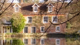
Lockerley Hall
Lockerley Hall was built 1839 - records of earlier buildings on the site exist from 1496 - funded by the fortunes of the Dalgety family who operated a large business in flour at the time. The Dalgety family funded the establishment of the original Lockerley and East Dean Memorial village hall and the rebuilding of the current Lockerley church.
Dating from around this time - the 15th century - is School Farm house whose core is a Wealden type house which has long since been provided with a brick façade as was the fashion in the 1700s. Go to Top
Black Horse
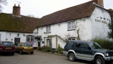 Parts of this collection of buildings that comprise the public house date from the mid 1600s. The present building combines a number of earlier buildings. The fireplace surround was rescued from the original Norman Court building when that was demolished. The present building at Norman Court is used for … who knows?. Go to Top
Other Old buildings
Many of these will be listed and thus subject to permission to change aspects of the building. The old farmhouse and the barn on stone blocks on Critchells Green dates from the 17th century.
Spring Cottage – aptly named as it located near a spring – was originally a pair of cottages which dated from the 16th century. They were damaged badly in a fire in 1966 and have since been restored and now heavily altered.
Cromwells was also a fine timber framed thatched cottage standing on the edge of Lockerley Green opposite the remaining timber framed house. Cromwells burnt down in the 1980s and has since been totally rebuilt using a sympathetic half timbered style.
The Old Smithy on Butts green is said to date from the 18th century as are two half timbered and thatched semi-detached cottages in The Street. Critchells Cottage – hidden behind a hedge and almost directly opposite the garage - may have timbers dating to the 15th century.
The Kings Arms was a public house but reverted to a private dwelling in 2016 is also located in The Street. It dates from the 18th century. Critchells House itself is set well back from the road and looks to be a mid 1800's building.
Visitors to West Dean my notice the sign for the Red Lion public house which has an interesting feature. The country boundary between Wiltshire and Hampshire passed through the public bar area. There was an era - well inside living memory, when the opening and closing times of public in different counties varied. It required drinkers to move a fraction of a metre to continue to drink legally.
There are timbers in one of the houses on Butts Green (the author knows which house) which have been dated to ca 1370. The house itself has witnessed rebuilding over the centuries.
The old signalling station, Telegraph House, dates from 1826 but it has since been extensively modified.
There used to be a mill at Dunbridge. It was steam powered but suffered a major fire in the early evening of 27 October 1939. The mill was operated by the Aylward family who also owned a number of properties in Lockerley. The mill was a major employer in the area at the time and the fire resulted in the loss of some 20 jobs. These days the Mill Arms remains as a hostelry and we trust it will remain as a pub and eatery. Go to Top
Basic Geology
The geology of this part of our local geography is a complex juxtaposition of geologically recent deposits belonging to the series Reading Formation. This in itself is a complex deposit of sandy clay, pebble beds and it is locally clay and glauconitic at its base. Above the Reading Formation is the younger London Clay Formation consisting of silty sandy clays, pebble beds and sand lenses.
Both formations lie uncomformably on the various chalk formations that we are familiar with surrounding the Hampshire Basin and Salisbury Plain. The underlying geology is Reading Beds, overlain with an inlier of London Clay. This has a strong influence on the extensive woodland cover and the high proportion of oak trees within the hedgerows. The area drains into the River Dun via a number of small streams. Small ponds and lakes are a feature of the area. Along the river Dun there is a number of springs. Some of these dry up during long hot summers but one or two are known as perpetual springs.
One, for example, always produces water adjacent to Spring Cottage another, the Blue Lagoon, is on the river Dun (or Dunne) between West Dean and Holbury. Despite the proximity to the Dun it is rare for any flooding to take place. In part this is a consequence of careful maintenance and management of the sluices between Holbury Mill and Lockerley Mill.
For springs to occur the ideal conditions are a permeable, (porous or pervious) layer of strata above an impermeable layer. In our area these factors would be expected to occur where the younger sandier London Clay Formation overlies the older clay layers of the Reading Formation. The water table will fluctuate beneath these formations and it will fall from about May to September when evaporation exceeds precipitation and vice versa from October to April when precipitation and percolation exceed evaporation.
A very good example of spring line settlements on a bigger scale is where the chalk South Downs lie above the clay vales of the north edge of the South Downs.
Glossary of terms
- The Reading Beds and London Clay belong to the upper section of the geological era called the Tertiary and sometimes called the Palaeogene. The period when they were deposited is called the Eocene from about 70 to 40 million years ago.
- Unconformity: A break in the geological record, recognised where a set of rocks is overlain by another set which is not the next in the geological succession.
- Water-Table: The upper surface of the zone of saturation in permeable rocks.
- Glauconite: A blue-green coloured iron potassium phyllosilicate mica type of mineral which is a common component of greensand and has a marine origins.
Prehistory
The history of Lockerley is like a gem with its many facets such as the geology, sociology, agriculture, surveys, population census and archaeology reports. We can start with maps and browse other topics.
Maps, both current OS and past maps, and their recent companions LIDAR maps, help to give a topological foundation for the area and perhaps this following suite of topics will fire up contributions that expand and correct the texts that follow (please identify your sources though). And, in appreciating an area there is nothing quite like the simplest technique - walking the patch. Happy rambling and happy reading. There is a short section of references set out but more would be appreciated. topology
To start the thinking here are two aerial views of the area. If you are keen to pick out features in the LIDAR scan here are some challenges to pick out.
Butts Green's triangular form can be recognised. The railway line is clearly visible with the bridge and the footpath access towards Spearywell Wood beneath it. The church of St John. The river Dun, its flood plain and the straight lines which indicate initial work on the canal. The early earth work - looks like a backward C. The indication of a long lost track from the earth work towards Holbury crossing what is now known as Critchells Green; it goes approximately ENE. The evidence of the railway sidings installed as part of D Day preparations.
The other image comprises, on the same scale, a merged version of the height variation with a colour image of the same area. Butts Green's triangular shape is a little more easily discerned. And, apologies, at this time the image covers only lower half of the LIDAR scan. North is up - as ever (not quite so with the LIDAR scan) - and the railway line should act as a guide if you try to line this up to an OS map. Then , if your interest is piqued, take some time out with the facility at the resource provided by the National Library of Scotland. Go to Top
The Name
The village name is known in the Domesday Book as Locherlega, 1086; Lokerlay, 1194; Lockerleye, 1271. Coates in 1989 suggested the name probably contains the Old English ancestor of Middle English lokere=looker possibly derived from the anglo saxon (with possible roman influence) of loca meaning enclosure. Lokere means keeper or shepherd and leah (from the Old English meaning a ley or open place in a forest) thus maybe indicates a shepherd's clearing or wood. Go to Top
Before the Normans
Lockerley has been known as a habitation since iron age times as earthworks in the area testify. Lockerley Camp – to the left on the road from Lockerley to Awbridge at Ordnance Survey reference SU 304 259 and approximately between Canefield and The School Farm – is a univallate nearly circular earthwork of 2.1ha, situated on a low gravel-capped plateau though it has been reduced by ploughing.
A keen eyed, and experienced archaeologist, will often find items such as a flint arrowhead when walking along the footpath between the Old Post Office and the railway bridge. Archaeological findings in the Lockerley area include some roman coins and pottery dating around AD 259-350 which were found in an earthwork near Holbury Farm known as Holbury Wood Camp. Palaeolithic artefacts have been recovered from gravel pits at nearby Dunbridge and Kimbridge. A recent digging foundation for a garden wall revealed some mesolithic stone implements and this suggests that Lockerley and its area has been in the flux of human activity and live since before 4000BC.
The image in the head of this section shows a LIDAR map and resulting topological map that shows this well. Go to Top
Norman period
The Domesday Book of 1086 records three manors and one hide (a hide is an area of land approximately equal to 120 acres) as belonging to the Bishop of Winchester. The manors were held by an overlord who, in turn, leased them to an underlord; this is known as alod. Prior to the Norman invasion of 1066 someone called Star (Sterre) held the manor from Edward the Confessor (b ca 1003 and ruled 1042 till his death in January 1066) in what was called alod (a freehold not held by the sitting lord). We might suggest that this name lives on in the name of the Star Inn which is located between East Tytherley and Lockerley but there is no evidence for this.
Following the Norman conquest the lands came into the possession of Hugh de Port as part of his 55 manors in Hampshire (Hantscire). The Domesday Book entry records that the land of Hugh de Port was located in the Broughton (Brocton) hundred (a hundred being an area of land equal to 100 hides) and included a manor in Lockerley which Star held from King Edward in freehold as a manor. Then (1066) and now (1086) it paid tax for one hide, land for three plough and, in lordship, one plough, four small holders and four slaves with half a plough. A mill at 10s (a shilling is equivalent to 50 pence), meadow six acres and woodland at three pigs. Star also held one hide which was part of the king's forest. This latter reference possibly indicating the extent to which the New Forest was at that time established.
A second manor had been held by one Wulfric from King William (the conqueror) and his father apparently held it from King Edward (the confessor). Wulfric had inherited one hide from his father and this was located in East Tytherley. A third manor was held by one Alfwy who held it from the king and who, prior to 1066, held in alod from King Edward.
For greater accuracy and a better overall view it may be useful use tithe (aka tythe) maps to study the land ownership at this time over the area including Broughton, Mottisfont, East and West Dean, Lockerley, East and West Tytherley, Sherfield English. These maps are early surveys on behalf of the land owner that identify field boundaries, their usage and their area (approx 2.5ha to an acre). The were used to set the tithe, tax or rent that the lease holder needed to return to the landowner. Go to Top
Boundaries
The village is possibly the conflation of three populations which may have existed as identifiably separate entities 1000 years ago. Lockerley, as it is presently known, is the main village and is centred around Butts Green. A second village called Lockerley Green seems to have existed at some period in the middle ages.
Lockerley Green is adjacent to a hamlet known as Holbury. Lockerley Green still exists by that name though it is now one of Lockerley's four principal greens and is part of the overall Lockerley parish. Holbury was, at times past, considered part of East Tytherley. East Dean parish might have included the area on the west side of Lockerley Green and it still includes habitations on the southside of the railway line which are reached from Lockerley's Top Green.
This confusion seems to have persisted until quite recent times until it was decided to place the west side of Lockerley Green within Lockerley parish. East Dean parish boundary was moved a small distance and now no longer bisects a house on the corner of the green and East Dean road. It includes some property on either side of the railway line which would otherwise be considered as being on the Top Green of Lockerley but, technically is in East Dean. Go to Top
The people and population
The village has some 324 dwellings which are home for around 827 people (2001 census). Butts Green owes its name to the period following 1538 - the period of the dissolution of the monasteries, when a royal decree required each able bodied man to spend an hour each Sunday at archery practice. The archery target is known as the butt from the old french “but” and this is meaning of a target is one which the modern french word retains. The law is still in force though few observe it; indeed, one doubts that current Health and Safety regulations would permit it and the carrying of arms in a public place would be a hazard - such be life.
The Glebe Field is leased to the Parish Council as a facility. It is, in essence, a sort of managed common land. It can be used by scouts and guides who may use the scout hut and its resources particularly in summer months when the field is used for camping and, for that reason, if no other, walking dogs on it is forbidden in any season.
If you are responsible for a dog please take its output home with you for safe disposal. Such stuff does not belong hanging in plastic bags on twigs or kicked to the undergrowth. There is no dog shit fairy.
This may go some way - only - to explaining why the Lockerley church - the original building of which was established ca 958 AD - is so far from the population centre of either major parts of the village and explains why Lockerley village is possibly one of the larger village parishes in Hampshire in terms of the area covered. As is apparently not uncommon the site of the church might be co-located with earlier roman places of worship. Go to Top
You might like to check out the Lockerley Old Mechanicals and make contact with our local history enthusiasts.
References include:
- The Church of St Winfriþ, A Very Short Guide to a Very Long History, Kate Clark, 2010, locally published.
- Lockerley a Village History, G Timmins, available in Romsey Library
- Victoria County History of Hampshire vol 4 Ed W Page, 1911, pp500 - 502.
- Concise Oxford Dictionary of Place Names 4th ed, Eckert , E K Wall, p302
- Domesday Book, Phillimore, Ed J Morris
- Hampshire Record Office, Winchester
- The Hampshire Subsidiary Rolls 1586, C R Davey
- The Hampshire Hearth Tax Assessment 1665, E Hughes and P White
- Parson and Parish in 18th century Hampshire, W R Ward
- Hampshire Treasury, Hampshire County Council
- Register of William Edington Bishop of Winchester 1346 - 1366, Ed dom S F Hockey#
- Rural Life in the Dun Valley 1066 - 1900, Margaret Baskerville, pub 2010 Margaret Baskerville SP5 1QD, ISBN 978-0-9566392-0-2 (available from Romsey Library). This is a well researched tome.